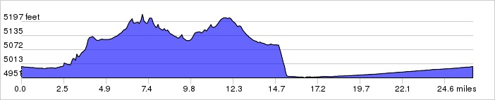
This route climbs on
bike trails up the West Mesa to Boca Negra Canyon before rolling the
hills of the Unser Bike Lanes. Descend Atrisco Hill and follow the
shady, flat route back to the start.
Distance: 26.2 miles, 481 ft. elevation gain.
Getting There: This ride starts at Alameda Open Space.
Roadway: Mostly bike paths, lanes and 2-lane roads.
| Available
Downloads |
|||||
| MAP | CUE SHEET | TCX
COURSE (Turn by turn directions) |
GPX
TRACK (Breadcrumb trail) |
GPX
ROUTE (Cuesheet waypoints) |
Route
on RideWithGPS.com |