This route traverses the perimeter of Albuquerque east of the Rio Grande, with a couple of rest stops included.
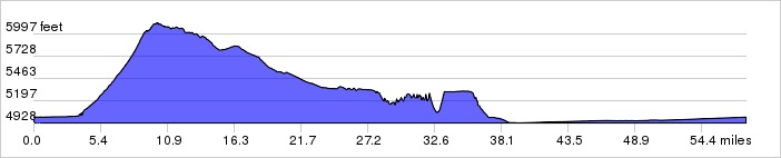
Distance: 58.0 miles, 1,893 ft. elevation gain.Getting There: This ride starts at the Alameda Open Space parking lot.
Roadway: Mostly stays on bike routes and trails.
Available Downloads
MAP CUE SHEET TCX COURSE
(Turn by turn directions)
GPX TRACK
(Breadcrumb trail)
GPX ROUTE
(Cuesheet waypoints)
Route on
RideWithGPS.com