|
 |
|
Gila Inner Loop Super Tour Options Map |
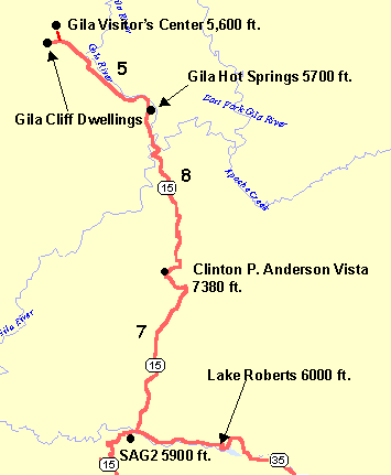
The 4% climb from the intersection of NM35/NM15 to the Gila Overlook is steep but is a pleasant climb through ponderosa
pine forests. The two overlooks give nice views of the Gila Wilderness. Then it is all downhill back to the intersection
(well, one small uphill). It is worth the effort.
The climb from the NM35/NM15 junction to the overlook, down to the Gila Cliff Dwellings, then back to the intersection
is a challenging ride, with 3500' elevation gain and about 37 miles (round trip). The climb out is steeper, about
6%, and open so you are exposed to the heat. Make sure to load up with water at the visitor centers since it is
usually quite hot even in May.
Once back at the intersection it is still 14 miles to Camp Thunderbird and there are climbs past Lake Roberts
and over the Continental Divide.
Roadway: The
roads are all paved rural 2-laned roads with no shoulders and very light traffic. The pavement from the overlook
down to the Gila Hot Springs is pretty steep and has annoying side-to-side cracks in the pavement.
Notes:
Gila Overlook Option Bikely.com
Interactive Map
Gila
Cliff Dwellings Option Bikely.com Interactive Map
Emory Pass Option
Gila Cliff Dwellings National Monument - There
is a nice short walk through the Cliff Dwellings, so bring cleat covers or sandals for the walk. There is water
at the cliff dwellings so top off there. The climb up is pretty steep, 6%, and there is no water until the store
at Lake Roberts. There is a nice NPS Visitor Center. There
is a bathroom at the first overlook. |